Tectonic Activity in The Region
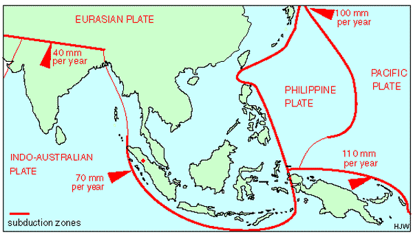
The Java trench is the result of the subduction zone caused by the Indo-Australian plate and the Eurasian plate. As this process of subduction occurs, massive amount of energy is stored and released resulting in very active and powerful seismic activity; One of the most powerful on Earth. The plate itself moves at a rate of 70mm per year.
The Indian plate moves at a faster rate than the Australian plate. It is generally accepted that an India-Eurasia related collision slowed northward. Indian plate motion, an upper plate motion, occurs at the Java trench causing the entire Sunda-Java margin to be affected by compression. The change in motion at the Java region is a consequence of extrusion tectonics cause by the India collision. The subduction of bathymetric features at the Java trench is widely accepted to cause broadly distributed deformation in the force arc. [1]

This chart shows the past earthquakes magnitude 7+ in the area, from 1975-2002.
Volcanism
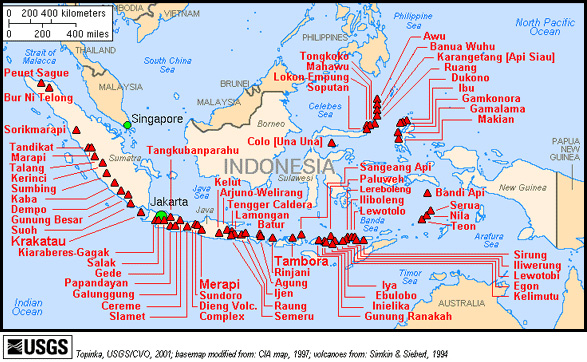
Many of the worlds most active Volcanoes are located in the area of Indonesia, around the Java Trench. Only those active since 1900 are shown in the map above. All of these Volcanoes occur as a result of the plate tectonics in the region.
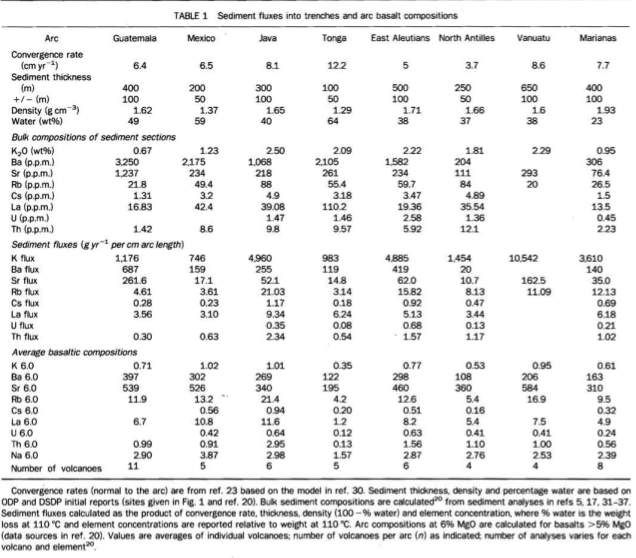
Sediment Distribution and classifications found in region
At ocean trenches, sea-floor sediments may either be scraped off the subducting plate, or accompany it into the mantle. At the Java trench, some of the subducted sediment may be recycled to the arc crust by magmatism due to volcanic activity.
(Letters to Nature,Vol 362, tracing trace elements from sediment input to volcanic output at subduction zones)
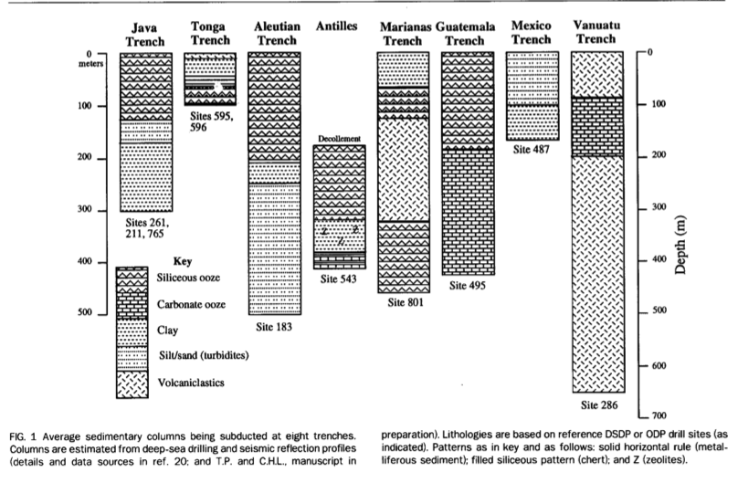
At the Java trench, the sediment generally goes from being siliceous ooze down until about 120 meters and then changes to silt/sand. At about 150 meters down it then changes to clay.
Bathymetry
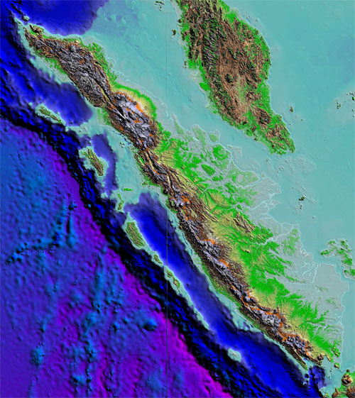
Bathymetry is the study of ocean depth and it's features. One would think that the Java trench would just simply be a trench in the ocean floor, with two plates converging at the site. But a bathymetric model shows so much more. These sonar images of the ocean crust show a pattern of normal faults typical of outer wall of trenches. This related to the bending of the oceanic lithosphere into the subduction zone. Another feature seen by the Java trench are a number of sub-circular seamounts. Isolated “ponds” of flat-lying sedmidents occur in the trench axis. Where subducting seamounts are colliding with the wedge, large crescentic areas of very high backscattering correlate with re=entrants in the deformation front and large indentations in the wedge. All sediment ponds in the trench axis occur in close association with collision scars, which suggest localised erosion.[2]
[1](www.sciencedirect.com)(Earth and Planetary Science Letters 255 (2007) 445-457)
[2](http:// www.sciencedirect.com/science/article/pii/004019519090404v)
[3](http://www.andaman.org/BOOK/originals/Weber-Toba/ch1_intro/text1.htm)
[4](USGS caption or http://www.andaman.org/BOOK/originals/Weber-Toba/ch1_intro/text1.htm)
[2](http:// www.sciencedirect.com/science/article/pii/004019519090404v)
[3](http://www.andaman.org/BOOK/originals/Weber-Toba/ch1_intro/text1.htm)
[4](USGS caption or http://www.andaman.org/BOOK/originals/Weber-Toba/ch1_intro/text1.htm)
