Ocean Cirulation/Regional Currents
Trade winds in this area blow to the northwest towards the equator, also known as the easterlies. These winds tug at the surface water of the ocean, causing a mass flow of water in this direction as well. This circulation of water is part of the Indian Ocean gyre. Sea-surface temperatures in the Indonesian area are always warm, adding to it’s tropical climate. Major surface currents that travel through the area of the Java Trench are all warm-water currents: the North Equatorial Current, Equatorial Counter Current, and the West Australian Current being 3 of them.[1]
Tidal Patterns
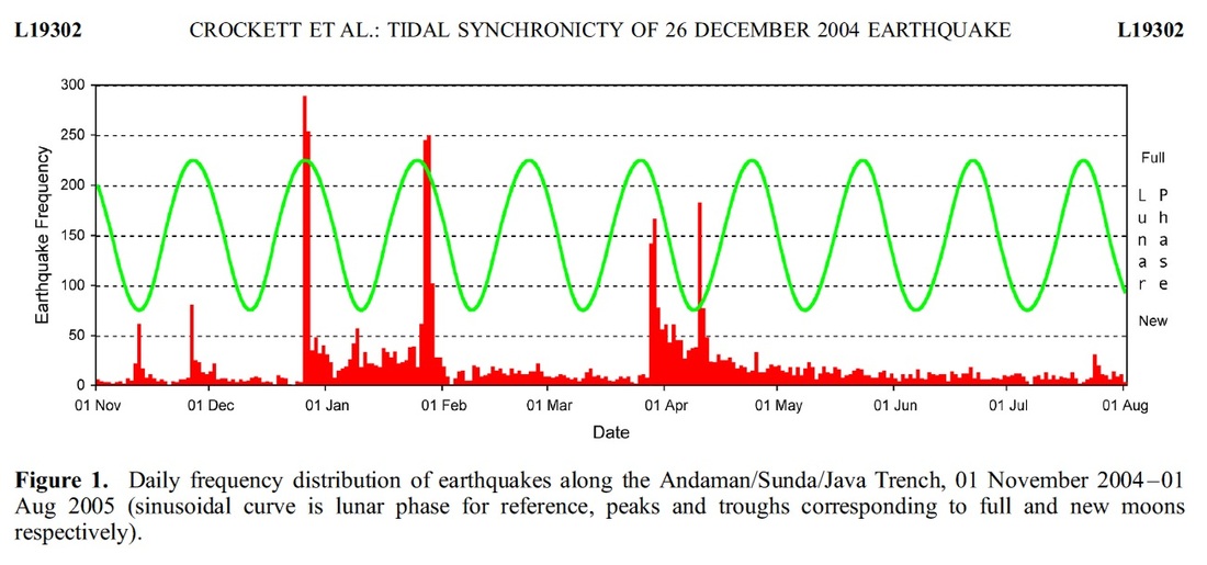
The Java Trench experiences many rare tidal patterns as a result of its location. Ocean tides, as we know it, are driven between the gravitational pull of both he Moon and the sun. During a full or new moon, Spring tides occur, causing the highest of high tide and the lowest of low tides. The area of Indonesia closest to the Java Trench have what is called a mixed tide; successive high tides or low tides are of strikingly different heights throughout the cycle due to diurnal and semidiurnal tides blending together. During the full or new moon large masses of water are loaded and unloaded at the plate boundary in the Indian ocean which could trigger earthquakes.
During this time frame variations in earthquake activity correlated with tidal force cycles. On December 26th 2004 an earthquake had occurred after a full moon. [2]
During this time frame variations in earthquake activity correlated with tidal force cycles. On December 26th 2004 an earthquake had occurred after a full moon. [2]
Atmospheric Circulation
Tropical Hadley cells cause cool air traveling down towards the equator to rise up as warm air, and at the equator is a low-pressure belt, also known as doldrums. Due to the Coriolis Effect, surface wind is deflected to the right, completing it’s circuit at an angle. Strong heating in the doldrums (or ITCZ, intertropical convergence zone) causes surface air to expand and rise. This humid air rises and then becomes rain, which is why is rains in large amounts in the area of the Java and Indonesia, and it is also what contributes to the tropical rain forests found in these areas. Western Sumatra, Java, Bali, the interiors of Kalimantan, Sulawesi, and Irian Jaya are the most predictably damp regions of Indonesia, with rainfall measuring more than 2,000 millimeters per year. In part, this moisture originates on strategically located high mountain peaks that trap damp air.
The main variable of Indonesia's climate is not temperature or air pressure, but rainfall. The almost uniformly warm waters that make up 81 percent of Indonesia's area ensure that temperatures on land remain fairly constant. Split by the equator, the archipelago is almost entirely tropical in climate, with the coastal plains averaging 28°C, the inland and mountain areas averaging 26°C, and the higher mountain regions, 23°C. The area's relative humidity ranges between 70 and 90 percent.
Because of the region’s positioning in the world, there are a few anomalies and weather patterns that cause natural disasters. Monsoons happen in the area, with the wet season occurring from August to February from mainland Asian and Pacific Ocean air masses, and the dry season being influenced by the Australian continental air masses. In general, western and northern parts of Indonesia experience the most precipitation, since the north- and westward-moving monsoon clouds are heavy with moisture by the time they reach these more distant regions.
This is also a zone of high humidity and warm air, which are over a sea surface that can exceed 79 degrees Fahrenheit. These conditions can develop tropical cyclones.
Another anomaly is the effect that “El Nino” or the Southern Oscillation Cycle has on the region. When pressure is high over the Pacific, it tends to be low in the eastern Indian Ocean-Indonesian region. The Eastern Indian Ocean is normally a low-pressure atmospheric zone. The other phase of the cycle, however, can bring drought to the Indonesian area. [3]
[1]pg. 172-173, 176
[2](Oceanography , vol 20, no.1, ripple marks)
[3](http://countrystudies.us/indonesia/29.htm)
